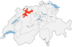
The canton of Solothurn is a very pleasant region for hiking along the river or on the summit of the Weissenstein. Its capital is a beautiful baroque town where Italian grandeur is combined with French charm and Swiss-German bonhomie.
The town of Solothurn, known as the "City of Ambassadors", is situated on the banks of the River Aare at the foot of the Jura, about 30 kilometres east of Biel.
The romantic, shady Verena Gorge, which is somewhat remote from the city, has a chapel and a hermitage that walkers love to visit, while hikers and cyclists will find an extensive network of hiking trails and no less than 600 km of cycling routes in the vicinity and along the Aare.
Other highlights of the canton are the Aare cruises and mountain walks. In summer, a boat passes through Altreu with its stork colony, Büren with its old town listed in the Federal Inventory of Cultural Property of National Importance, and continues to Biel.
The Weissenstein, a 1291 metre-high peak in the Solothurn Jura, offers a beautiful panorama of the Mittelland and the Alps, with plenty of opportunities for hiking and mountain biking and, in winter, cross-country skiing and sledging.
As is often the case in Switzerland, the canton of Solothurn is very indented and has some "exclaves", a tiny one in the south (part of the canton of Bern) and two larger ones in the north, on the French border, wedged between the canton of Basel-Landschaft and Alsace.
 |
The Pictorial Guides
© fusions.ch 1988-2025
All rights reserved for all countries |

|


